Philatelic Literature Specialists
-
General Philatelic
- Airmail
- Auction Catalogues
- Bibliographies
- Bilig Philatelic Handbooks
- Cinderellas
- Exhibitions & Congresses
- Forgeries
- Fred J Melville
- General Handbooks
- History of Philately
- Jean-Baptiste Moens
- Maritime
- Military
- Polar
- Postal History
- Postal Stationery
- Postmarks
- Railways
- Specimen Stamps
- The Royal Philatelic Society, London
- Thematics
- Vintage Catalogues
-
Great Britain
- Airmail
- Channel Islands
- Cinderellas
- Edward VII Issues
- Edward VIII Issues
- George V Issues
- George VI Issues
- Ireland
- Isle of Man
- Local Postal History
- London
- Maritime
- Military
- Perfins
- Post Office History
- Postal History
- Postal Stationery
- Postmarks
- Pre-adhesives
- QEII Issues
- Queen Victoria Issues
- Railways
- Scotland
- Telegraphs/Telephones
- Used Abroad
- Wales
-
British Commonwealth
- Aden
- Antigua
- Ascension
- Australia
- Bahamas
- Barbados
- Basutoland
- Batum
- Bechuanaland
- Bermuda
- Britis Central Africa
- British East Africa
- British Empire - General
- British Guiana
- British Honduras
- British North America
- British Occupied German Colonies
- British Occupied Italian Colonies
- British Solomon Islands
- British West Africa
- British West Indies
- Brunei
- Burma
- Cameroons
- Canada
- Cape of Good Hope
- Cayman Islands
- Ceylon
- Christmas Island
- Cocos (Keeling) Islands
- Cook Islands
- Cyprus
- Dominica
- Egypt
- Falkland Islands
- Fiji
- Gambia
- Ghana
- Gibraltar
- Gilbert & Ellice Islands
- Gold Coast
- Grenada
- Heligoland
- Hong Kong
- India
- Ionian Islands
- Iraq
- Jamaica
- Kenya
- Labuan
- Lagos
- Leeward Islands
- Levant
- Long Island
- Madagascar
- Mafia
- Malaya
- Malta
- Mauritius
- Montserrat
- Morocco Agencies
- Natal
- Nauru
- Nevis
- New Hebrides
- New Republic
- New Zealand
- Niger Coast
- Nigeria
- Norfolk Island
- Noth Borneo
- Nyasaland
- Orange Free State
- Pakistan
- Palestine
- Papua
- Pitcairn
- Rhodesia
- Saint Vincent
- Samoa
- Sarawak
- Seychelles
- Sierra Leone
- Somaliland
- South Africa
- South West Africa
- St. Christopher
- St. Helena
- St. Kitts
- St. Lucia
- Straits Settlements
- Sudan
- Swaziland
- Tanganyika
- Togo
- Tokelau
- Tonga
- Transvaal
- Trinidad & Tobago
- Tristan da Cunha
- Turks & Caicos Islands
- Uganda
- Vanuatu
- Virgin Islands
- Zanzibar
- Zululand
-
Europe & Colonies
- Aaland Islands
- Albania
- Andorra
- Armenia
- Austria
- Azerbaijan
- Belgian Congo
- Belgium
- Bosnia
- Bulgaria
- Crete
- Croatia
- Cyprus
- Czechoslovakia
- Danish West Indies
- Danzig
- Denmark
- Estonia
- Europe - General
- Finland
- France
- French Colonies
- German Colonies
- Germany
- Gibraltar
- Greece
- Greenland
- Heligoland
- Hungary
- Iceland
- Ionian Islands
- Ireland
- Italy
- Latvia
- Liechtenstein
- Lithuania
- Luxembourg
- Malta
- Memel
- Moldavia
- Monaco
- Montenegro
- Netherlands
- Norway
- Poland
- Portugal
- Roumania
- Russia
- San Marino
- Serbia
- Slovakia
- Slovenia
- Spain
- Sweden
- Switzerland
- Thurn & Taxis
- Turkey
- Ukraine
- Upper Silesia
- Vatican
- Yugoslavia
- The Americas
-
Africa
- Abyssinia
- Algeria
- Angola
- Basutoland
- Bechuanaland
- Belgian Congo
- British East Africa
- Cameroons
- Cape of Good Hope
- Egypt
- Ethiopia
- French Equatorial Africa
- Gambia
- German East Africa
- Ghana
- Gold Coast
- Kenya
- Lado Enclave
- Lagos
- Liberia
- Libya
- Madagascar
- Mafia
- Mauritius
- Morocco
- Mozambique
- Natal
- New Republic
- Niger Coast
- Nigeria
- Nyasaland
- Orange Free State
- Rhodesia
- Seychelles
- Sierra Leone
- Somaliland
- South Africa
- South West Africa
- Sudan
- Tanganyika
- Togo
- Transvaal
- Tunisia
- Uganda
- Zambia
- Zanzibar
- Zululand
- Asia
- Middle East & Levant
- Journals
- Non-philatelic
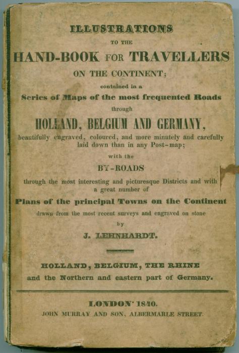
Illustrations to the Hand-book for Travellers on the Continent;
First edition, hardback, original printed boards, 17 pages, [2] publisher’s list, title printed on both upper and lower boards in English and German, one general double-page map before title-page, 21 folding colour-outlined maps with town plans, 8 separate town plans, list of maps on front paste-down endpaper, completely lacking the cloth backstrip (spine) and the silk ties, light foxing to the versos of the maps, one inner-hinge very slightly cracking. Complete with all the maps and pages as called for, would benefit from re-binding. In Good condition.
Published as a companion to Murray’s ‘Hand-book for Travellers on the Continent’. Includes a list of the principal hotels and inns along the routes shown on the maps; taxes for posthorses, postillions and Waggonmasters; and a table of comparative values of German and foreign coins.
£250.00
Out of stock
![]()
© 2025, HH Sales.
Website by Paper Street.